Constructive topics of interest related to aviation that do not match the other section descriptions below (as long as it is somewhat related to aviation, flying, learning to fly, sport pilot, light sport aircraft, etc.). Please, advertisements for Viagra will be promptly deleted!"
I was musing with a chart around some of my old stomping grounds and came across map symbols that I don't recall seeing before... Having flown there it is even more perplexing that I do not recall anything that jumps out of that area
What I am referring to are the tick marks around the BEARCE (7M3) airport west of Hot Springs.
Image1.jpg (72.19 KiB) Viewed 13660 times
My thinking is that they are bluffs/cliffs but just don't really know.
If you are talking about the circle segment that your green dot is on, then that is an exclusion for airspace in the MOA 1500 foot and below for the airport.
3Dreaming wrote:If you are talking about the circle segment that your green dot is on, then that is an exclusion for airspace in the MOA 1500 foot and below for the airport.
No, that's actually Class E to the surface. Has nothing to do with MOA which that airport is not in. It's for IFR protection from VFR traffic in low weather conditions. They don't want any VFR aircraft making takeoffs and landings with Class G minimums (1 mile, clear of clouds).
PS: The green dot is iFly GPS depiction for VFR weather.
EDIT: Yes, you are correct. We're looking at two different airports and two different green dots.
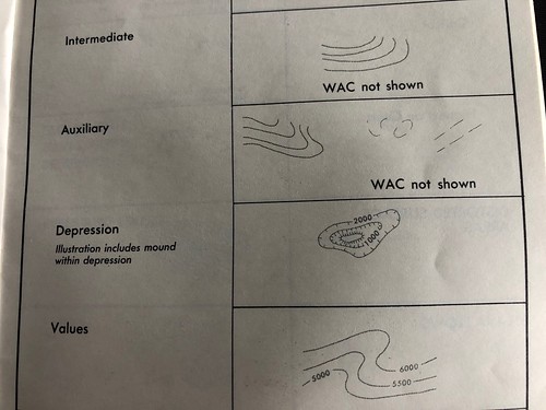
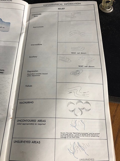
Sorry I should have stressed it is the topographical symbol that baffles me.
I know the depression symbol, tick marks on the inside, toward the lower ground. But these are on the outside and the ground enclosed is higher plus I do not recall ever seeing that symbol used before.
I fly over that area a time or two a year on my way to KORK and that area a bit south of 7M3 looks to be where there is a pretty deep and narrow valley. Maybe that's the 'depression'?
TimTaylor wrote:
Another clue, one is named Mount Ida.
Ida know about that.
The opinions posted are those of one CFI, and do not necessarily represent the FAA or its lawyers.
Prof H Paul Shuch
PhD CFII DPE LSRM-A/GL/WS/PPC iRMT
AvSport LLC, KLHV [email protected]
AvSport.org
facebook.com/SportFlying
SportPilotExaminer.US